Real-time Seismic Amplitude Measurement (RSAM)
What is RSAM?
Real-time Seismic Amplitude Measurement (RSAM) was developed by the United States Geological Survey (USGS) to summarize seismic activity (See
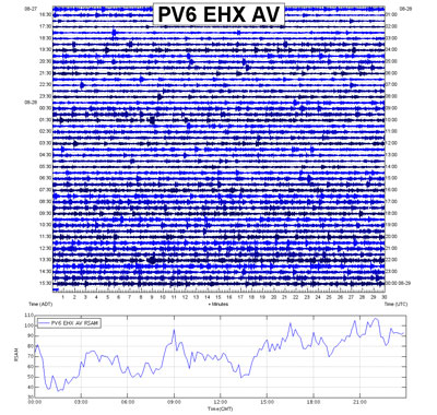
this site for more info). It was initially developed for those locations near volcanoes that were seeing increased seismic activity. The figure to the right shows the 24-hour raw seismic data (also know as a webicorder) at the top, and the intepreted RSAM values for the same 24-hour period on the bottom. RSAM takes thousands of data points per second and "averages" the data into 30-second bins.
While it was initially developed to detect volcano reawakening, RSAM is also useful for detecting other geologic events, like debris flows, at Mount Rainier. Here at Mount Rainier, we use RSAM on the Emerald Ridge (RER) seismograph to help detect debris flows and rock falls. These large events have the potential for damaging park infrastructure and endangering visitor and employee safety. Together with the Univeristy of Washington, the RSAM script is run at 10 minute intervals. If the RSAM value exceeds a certain amount (500) for a certain time frame (5 minutes) and the signal strength is increasing (slope > 1), an alert is generated to park geologists and park dispatch. This waveform is typical of a debris flow, but the algorithm can also generate false-positives. Quick peaked events on the graph above may be regional or local earthquakes, rock falls, or seismic equipment calibration. We don't care about those events (generally); instead, we are looking for an event that is increasing in its signal strength over a period of 5+ minutes - this could be a debris flow.
The long term goal of this project is to be able to detect debris flows within 5-10 minutes of their generation in Tahoma Creek, and in turn, provide some sort of warning about the event to those people working or recreating in the Tahoma Creek basin downstream of the South Tahoma Glacier.
This system is currently being developed and changes are likely. Stay tuned for more info!
Console Viewer
If you have a computer screen and want to see real-time updates to the RER RSAM data (and Longmire and White River stream gages), click the following link:
http://rsam.morageology.com/console.php
Archived Data
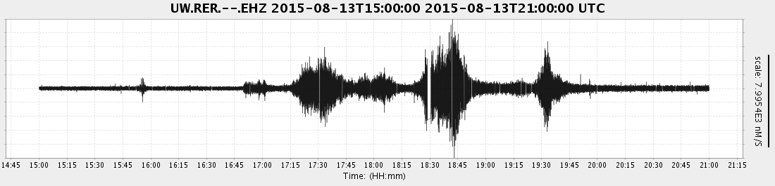
For those that are curious, here are the debris flow signatures from August 13 and September 12 (September 13 in UTC time), 2015... this is the raw seismic data:
August 13, 2015 (4 Debris Flow Sequences between ~16:45 - 19:45 UTC)
 September 13, 2015 (1 Debris Flow sequence between ~00:25 - 00:45 UTC)
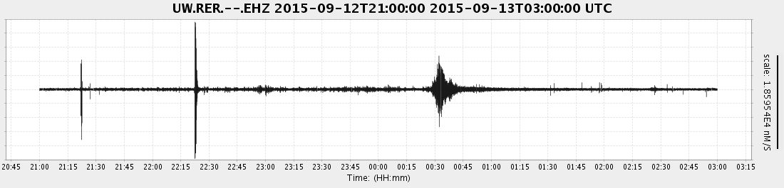
The RSAM algorithm searches for the waveform that you can see in the above images.